|

 |
 |
 |
 |
Upcoming Expeditions |
 |
 |
 |
 |
MountainRec Newsletter
Web page under Winter re-construction)
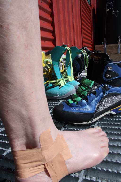
Taping my Ankles for Performance
24-12-2012
GW has just purchased a pair of La Sportiva Trango's (1200gms) and worn them on two recent climbs on Aspiring and Cook. Concerned about the extensive cramponing on Cook last week I pre-taped my ankles to gain more rigidity within the lightweight boots. I'd previously done this on a GT and it again worked very well. Note: the closed cell foam in the laces to give warmth and waterproofness.
POSTCARD from the Ledge
No waste of paste - A cut-off toothbrush & tube seen at Plateau hut

Plateau hut Loo ph:Geoff W

Alpine Loos with View & sometime -phew!
GW Mt Cook summit portraits


Nov 15 1982 05 Nov 2012 (24 in 46 @ 66)
GW Aoraki/Mt Cook highlights:
Historically, NZ,s highest peak is an iconic focal point since its 1st ascent by Fyfe, Graham & Clarke on 25th Dec, 1894.Then known as Mt. Cook or Aorangi (the cloud-piercer) with height of 12,349ft measured by Surveyor G.J Roberts in 1881.
Note: Traditionally peaks are measured by the highest point seen, either rock or snow. Now, very accurate measurement can be done by satellite.
Following the Dec 1991 rock/snow avalanche, the summit was lowered by 10mtrs to 3754m. Weather & erosion further lowered it to the current height of 3724m (as confirmed 23 Nov 2013 )
Hawea Conservation Area -NEW day trips from Wanaka.
Pakituhi Hut (2-1/2hrs) Breast Peak (4hrs)
The track starts 3klm north of Johns creek and zig-zags up steep gully to low saddle. A long narrow spur with steep drop-offs and brilliant views leads to the skyline ridge and Pakituhi hut (sleeps 8). The views from ridgeline and Breast Peak are spectacular, including Mt. Aspiring.


A recent review of Surveyor Thompson's naming of Aspiring (3033m)from Mt. Grandview has questioned. "Did he actually think Aeolus(2284m) in the Wilkin valley was Aspiring. See what you think?


aspiring aoelus
Corner Peak
The track starts 100m past Timaru Creek through some manuka bush to a sidling 4whl track for a klm or so. A poled route leads up steep grassed tussocks to the ridge at 1100m (approx. 2hrs from road). A pleasant ridge walk leads to peak 1410m. with spectacular views of Corner Peak, Lake Hawea and Hunter valley. (1/2hr)

Corner Peak from Peak 1410m (L.hawea to left and hunter valley to right)
Mountain Photo Gallery page: Geoffs Photos

M.M. The Worlds most celebrated rockclimber?
Have a an energetic summer and may the high pressures be with you,
Geoff & Beryl W
Email: mailto: mountainrec@mountainrec.co.nz
NZ Southern Alps Weather
Current Weather Maps for New Zealand
Today's Weather Map
Long Range Forecast Weather Maps
Animated Long Range Forecast Weather Maps
Currrent Weather Forecasts for New Zealand
New Zealand Mountain Forecast - Met Service
New Zealand Short Forecast - Met Service
(today and tomorrow)
New Zealand Extended Short Forecast - Met Service
(the day after tomorrow and two days after that)
Other Useful Weather Sites
Global Satellite Photos (from NASA)
(click on New Zealand for the NZ Satellite Photo)
Victoria University (Wellington, NZ) Meteorological Site
University of Canterbury (NZ) Geography Department
National (NZ) Institute of Water & Atmospheric Research (NIWA)
(home) (upcoming expeditions) (about mountain rec) (geoff wayatt profile) (mt aspiring guided treks) (climbing courses)
(mnt rec's avalanche lodge) (geoff's mountain photo's) (mail order equipment sales) (tips, trix, and topos)
(previous expeditions) (technical mtn. notes) (weather & avalanche notes) (registration form) (contact us)
(latest news and weather)(newsletter)
email: mountainrec@mountainrec.co.nz